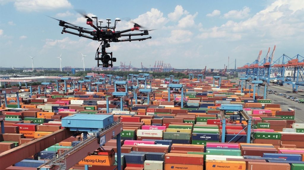
Pour inspecter les installations de Hamburger Hafen und Logistik AG, aussi appelé HHLA, l’équipe de recherche AeroInspekt de la TU Braunschweig a développé un système associant une caméra aérienne Phase One iXM-100, une optique RSM de 150 mm et un drone DJI M600 Pro.
Grâce à cette configuration, l’équipe pouvait collecter des images très détaillées pendant le fonctionnement du terminal. Elle réduisait ainsi les arrêts nécessaires aux relevés traditionnels réalisés depuis le sol.
Pourquoi inspecter les rails d’un terminal portuaire ?
Les portiques automatisés jouent un rôle central dans le déplacement et le stockage des conteneurs. Ils circulent sur des rails installés dans différentes zones du terminal.
Cependant, le sol et les infrastructures peuvent évoluer avec le temps. Un tassement, un déplacement ou une déformation du rail risque alors de perturber le fonctionnement des grues.
Les équipes doivent donc contrôler régulièrement :
- la géométrie des voies ;
- l’alignement des rails ;
- les éventuels déplacements du sol ;
- les variations de hauteur ;
- les zones nécessitant une analyse complémentaire ;
- les changements observés depuis le relevé précédent.
Chez HHLA, l’inspection annuelle concerne plus de 30 km de rails par terminal. Une telle distance rend les opérations longues, surtout lorsque les relevés imposent l’arrêt des portiques.
Les limites d’une inspection traditionnelle réalisée au sol
Une inspection terrestre nécessite généralement la présence de techniciens à proximité des rails. Les équipes doivent alors sécuriser la zone et interrompre temporairement certains mouvements.
Cette organisation entraîne plusieurs contraintes. Tout d’abord, elle ralentit l’activité du terminal. Ensuite, elle expose les opérateurs à un environnement où circulent des équipements lourds.
De plus, un relevé réalisé depuis le sol demande beaucoup de temps lorsqu’il couvre plusieurs dizaines de kilomètres. Les équipes doivent multiplier les positions de mesure et déplacer régulièrement leur matériel.
L’inspection par drone apporte donc une autre approche. Elle collecte des images depuis les airs, tout en maintenant une distance de sécurité avec les infrastructures.
Comment fonctionne l’inspection aérienne par drone ?
Le drone survole les rails selon une trajectoire définie avant la mission. Pendant le vol, la caméra capture une série d’images présentant un recouvrement suffisant.
Ensuite, un logiciel de photogrammétrie analyse les différentes prises de vue. Il identifie des points communs entre les images, puis reconstruit la zone inspectée.
Ce processus peut produire plusieurs types de données :
- des images aériennes en très haute résolution ;
- une orthophotographie de la zone ;
- un modèle tridimensionnel ;
- des mesures de distance et de position ;
- une comparaison avec les relevés précédents ;
- une base visuelle pour identifier les anomalies.
Ainsi, le drone ne réalise pas uniquement des photographies générales. Il devient un véritable outil de collecte de données pour les géomètres, les ingénieurs et les responsables de maintenance.
Une caméra Phase One iXM-100 de 100 mégapixels
L’équipe AeroInspekt a choisi la Phase One iXM-100 pour obtenir une définition élevée depuis une altitude de sécurité.
Cette caméra aérienne moyen format dispose d’un capteur de 100 mégapixels. Elle a été conçue pour les missions de cartographie, de photogrammétrie et d’inspection industrielle par drone.
Une résolution élevée présente plusieurs avantages. Elle permet notamment de couvrir une surface importante avec chaque image tout en conservant des détails suffisamment fins pour l’analyse.
Par conséquent, l’équipe réduit le nombre de passages nécessaires. Elle limite aussi le volume de manœuvres réalisées au-dessus du terminal.
Pourquoi utiliser une optique RSM de 150 mm ?
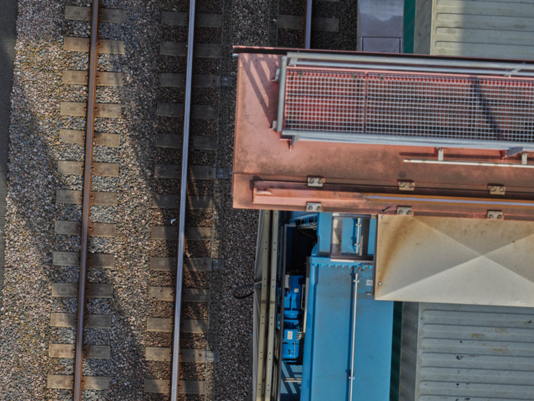
Le projet associait la caméra iXM-100 à une optique Phase One RSM de 150 mm. Cette longue focale permettait de photographier précisément les rails depuis une altitude suffisante.
À environ 35 mètres de hauteur, le système couvrait une largeur proche de 7,7 mètres par image. Il atteignait alors une résolution au sol proche du millimètre.
En volant plus bas, l’équipe pouvait encore augmenter le niveau de détail. Toutefois, la hauteur de vol devait rester compatible avec la sécurité, les mouvements des grues et les contraintes du terminal.
L’objectif RSM possède également une mise au point motorisée. Ainsi, l’opérateur peut adapter le réglage lorsque la hauteur ou la distance d’inspection évolue.
Une résolution proche du millimètre à 35 mètres
La résolution au sol, souvent appelée GSD, indique la surface réelle représentée par un pixel dans l’image.
Plus cette valeur est faible, plus l’image contient des détails précis. Dans le cadre du projet AeroInspekt, la configuration pouvait atteindre environ :
- 0,3 mm par pixel à une hauteur proche de 10 mètres ;
- 0,9 mm par pixel à environ 35 mètres ;
- une couverture d’environ 7,7 mètres de large à 35 mètres.
Ces valeurs dépendent néanmoins de la caméra, de l’objectif, de l’altitude et des conditions de la mission. Elles doivent donc être vérifiées pendant la préparation du plan de vol.
Grâce à cette finesse, les ingénieurs peuvent observer les rails avec un niveau de détail adapté aux mesures et aux comparaisons photogrammétriques.
Maintenir les grues en fonctionnement pendant l’inspection
L’un des principaux objectifs du projet consistait à réduire les interruptions d’activité. Contrairement à certains relevés terrestres, le système aérien pouvait intervenir pendant que les grues poursuivaient leur fonctionnement.
Cette continuité apporte un avantage économique important. En effet, chaque arrêt d’une zone de manutention peut ralentir le traitement des conteneurs et désorganiser les opérations du terminal.
Toutefois, une mission réalisée dans un environnement actif demande une planification beaucoup plus complexe. Le drone doit éviter les équipements mobiles, respecter les distances de sécurité et conserver une couverture complète des rails.
Pourquoi un plan de vol classique ne suffit-il pas ?
Lors d’une mission de cartographie traditionnelle, le drone suit souvent des lignes parallèles. Cette trajectoire régulière permet de couvrir toute la zone avec un recouvrement constant.
Cependant, cette méthode devient moins efficace dans un terminal où les portiques se déplacent en permanence. Une grue peut masquer une partie des rails au moment précis où le drone réalise une photographie.
Le jeu de données présenterait alors des zones cachées. Par conséquent, la reconstruction photogrammétrique resterait incomplète.
Pour résoudre ce problème, AeroInspekt a développé un système capable d’adapter la mission en fonction de la position et de la vitesse des portiques.
Une trajectoire recalculée dans un environnement dynamique
Le système surveille les éventuels conflits pendant la mission. Ensuite, il modifie la trajectoire lorsque les mouvements des grues risquent de masquer les rails ou de gêner le passage du drone.
Cette replanification prend en compte plusieurs contraintes :
- la position actuelle des portiques ;
- leur direction et leur vitesse ;
- les zones interdites au survol ;
- la couverture photographique déjà obtenue ;
- le recouvrement nécessaire entre les images ;
- les exigences du géomètre et de l’opérateur du terminal.
Ainsi, le drone ne suit pas simplement un parcours figé. Il adapte sa mission à un environnement qui évolue en permanence.
Quel matériel composait le système AeroInspekt ?
La configuration employée pendant cette étude de cas comprenait quatre éléments principaux :
- une caméra aérienne Phase One iXM-100 de 100 mégapixels ;
- une optique Phase One RSM de 150 mm ;
- un drone professionnel DJI M600 Pro ;
- l’application mobile Phase One iX Capture.
Le DJI M600 Pro assurait le transport de la caméra et de son système de stabilisation. De son côté, l’application iX Capture facilitait la gestion de la caméra pendant la mission.
Cette configuration correspond au projet présenté. Depuis sa réalisation, les gammes de drones, de caméras et de charges utiles professionnelles ont évolué.
Comment préparer une inspection aérienne d’infrastructure ?
Une inspection professionnelle ne commence pas au moment du décollage. Elle nécessite d’abord une préparation technique, réglementaire et opérationnelle.
- Définissez précisément les défauts ou les mouvements à rechercher.
- Déterminez la résolution au sol nécessaire à l’analyse.
- Choisissez la caméra et l’objectif adaptés.
- Calculez la hauteur de vol et la surface couverte par chaque image.
- Préparez le recouvrement longitudinal et latéral.
- Identifiez les obstacles fixes et les équipements mobiles.
- Coordonnez la mission avec l’exploitant du site.
- Vérifiez les autorisations et les règles applicables au vol.
- Installez les éventuels points de contrôle au sol.
- Préparez enfin le traitement et la sauvegarde des données.
Cette préparation garantit la cohérence des images. Elle évite également de devoir recommencer une mission en raison d’une couverture insuffisante.
Le rôle des points de contrôle au sol
Pour transformer les photographies en données mesurables, l’équipe doit relier le modèle photogrammétrique à un système de coordonnées fiable.
Des points de contrôle au sol peuvent donc être installés à proximité de la zone inspectée. Leurs coordonnées sont mesurées précisément avant le vol.
Ensuite, le logiciel identifie ces repères dans les images. Il peut ainsi positionner et mettre à l’échelle la reconstruction.
Toutefois, le nombre et la répartition des points dépendent de la précision recherchée, du système de positionnement utilisé et de la géométrie du site.
Comment traiter les images après le vol ?
Après l’acquisition, l’équipe vérifie d’abord la netteté, l’exposition et la couverture des images. Elle élimine ensuite les fichiers inutilisables.
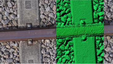
Le logiciel de photogrammétrie peut alors :
- aligner les différentes photographies ;
- calculer la position des prises de vue ;
- générer un nuage de points ;
- produire un modèle tridimensionnel ;
- créer une orthophotographie ;
- comparer les mesures avec les données historiques.
Enfin, les spécialistes interprètent les résultats. Ils identifient les variations significatives et décident si une inspection terrestre complémentaire devient nécessaire.
Quels sont les avantages de l’inspection par drone ?
Le projet AeroInspekt met en évidence plusieurs bénéfices :
- une collecte rapide sur plusieurs kilomètres de rails ;
- une résolution adaptée aux mesures détaillées ;
- moins d’interruptions dans le fonctionnement du terminal ;
- une réduction de l’exposition des équipes aux zones dangereuses ;
- une documentation visuelle complète de l’infrastructure ;
- une comparaison plus simple entre plusieurs campagnes ;
- une trajectoire adaptable aux équipements en mouvement.
De plus, les images constituent une archive durable. Les ingénieurs peuvent donc revenir sur les données après la mission et réaliser de nouvelles analyses.
Quelles sont les limites de cette méthode ?
Malgré ses avantages, l’inspection aérienne ne remplace pas systématiquement une intervention au sol. Certaines anomalies nécessitent un contrôle physique ou l’utilisation d’un autre capteur.
La qualité des résultats dépend également :
- des conditions météorologiques ;
- de la stabilité du drone ;
- de la netteté des images ;
- du recouvrement entre les prises de vue ;
- de la précision du géoréférencement ;
- de la maîtrise du traitement photogrammétrique ;
- du respect des règles de sécurité et de la réglementation.
Par ailleurs, un capteur de 100 mégapixels produit des fichiers volumineux. L’équipe doit donc prévoir un stockage rapide, des sauvegardes fiables et une puissance informatique adaptée.
Dans quels domaines utiliser une caméra aérienne haute résolution ?
Les solutions d’inspection Phase One ne se limitent pas aux terminaux portuaires. Elles peuvent également répondre à d’autres missions industrielles.
- inspection de voies ferrées ;
- contrôle de ponts et d’ouvrages d’art ;
- inspection de lignes électriques ;
- analyse de pales d’éoliennes ;
- suivi de routes et de pipelines ;
- cartographie de sites industriels ;
- inspection de bâtiments et de façades ;
- création de modèles 3D haute définition.
Dans chaque cas, le choix de la caméra, de l’optique et de la plateforme dépend de la taille de la zone, de la résolution nécessaire et des contraintes de sécurité.
FAQ sur l’inspection aérienne par drone
Qu’est-ce qu’une inspection aérienne par drone ?
Une inspection aérienne consiste à utiliser un drone équipé d’une caméra ou d’un autre capteur pour observer, mesurer et documenter une infrastructure depuis les airs.
Pourquoi utiliser une caméra de 100 mégapixels ?
Une caméra très haute résolution couvre une surface importante tout en conservant des détails fins. Elle peut ainsi réduire le nombre de photographies nécessaires pendant la mission.
Quelle résolution le système AeroInspekt pouvait-il atteindre ?
Avec la caméra iXM-100 et l’objectif RSM de 150 mm, le système atteignait environ 0,9 mm par pixel à 35 mètres et jusqu’à 0,3 mm à une hauteur proche de 10 mètres.
Pourquoi la mission concernait-elle plus de 30 km de rails ?
Les portiques automatisés des terminaux HHLA circulent sur un vaste réseau de voies. Chaque terminal nécessite donc l’inspection annuelle de plus de 30 km de rails.
Les grues devaient-elles s’arrêter pendant le vol ?
Le système a précisément été développé pour réaliser les relevés pendant le fonctionnement des portiques. La trajectoire devait cependant s’adapter à leur position et à leur vitesse.
Qu’est-ce que la photogrammétrie ?
La photogrammétrie utilise plusieurs photographies prises sous différents angles pour mesurer une zone et produire une reconstruction en deux ou trois dimensions.
Le drone remplace-t-il complètement l’inspection au sol ?
Non. Le drone permet d’identifier et de documenter rapidement les zones à surveiller. Une vérification terrestre peut néanmoins rester nécessaire pour confirmer certaines anomalies.
Quel matériel fut utilisé pendant ce projet ?
La configuration associait une caméra Phase One iXM-100, une optique RSM de 150 mm, un drone DJI M600 Pro et l’application Phase One iX Capture.
Une solution précise pour inspecter des infrastructures en activité
Le projet AeroInspekt démontre l’intérêt d’une caméra aérienne haute résolution dans un environnement industriel complexe.
Grâce au Phase One iXM-100, l’équipe pouvait recueillir des images proches d’une résolution millimétrique tout en conservant une altitude de travail adaptée.
De plus, la replanification dynamique de la trajectoire permettait de tenir compte des portiques en mouvement. Le terminal pouvait ainsi poursuivre une partie de son activité pendant l’inspection.
Enfin, cette étude de cas montre que la qualité du capteur ne suffit pas. La préparation du vol, le géoréférencement, le traitement photogrammétrique et l’analyse des données restent essentiels pour obtenir des résultats fiables.
Découvrez d’autres contenus PROPHOT
Consultez également notre article consacré à
l’utilisation du moyen format en photographie culinaire
ainsi que notre guide sur
la réglementation des drones en France
.
Source de l’étude de cas :
Phase One – AeroInspekt, inspection aérienne des rails
Article initialement publié le 13 août 2021 et mis à jour le 28/07/2026 par Enzo De
l’équipe PROPHOT.
Hello there! This blog post could not be written any better!
Looking at this post reminds me of my previous roommate!
He continually kept talking about this. I am going to
send this information to him. Pretty sure he will have a very good read.
Thank you for sharing!
I couldn’t refrain from commenting. Perfectly written!
Keep oon writing, great job!